
Precision Drone Stockpile
Volume Measurements
Revolutionary volumetric surveys using advanced drone technology and photogrammetry for accurate material stockpile analysis
Start Your SurveyAdvanced Volumetric Survey Solutions
Transform your inventory management with our cutting-edge drone technology and precise 3D modeling capabilities
3D Point Cloud Generation
High-resolution photogrammetry creates detailed 3D models of your stockpiles, enabling precise volume calculations with centimeter-level accuracy.
RTK GPS Precision
Our RTK-enabled drones combined with strategically placed Ground Control Points ensure survey-grade accuracy for all measurements.
Comparative Analysis
Track site progress over time by comparing current volumes to previous surveys and final grade design files for optimal material management.
Rapid Deployment
Complete aerial surveys in hours instead of days, minimizing disruption to your operations while maximizing data collection efficiency.
LiDAR Integration
Advanced light detection and ranging technology creates highly accurate point clouds even in challenging vegetation or lighting conditions.
Real-Time Reporting
Access your volumetric data through interactive dashboards and detailed reports, enabling informed decision-making on the go.
Advanced Analysis in Action
Real-world examples of our volumetric measurement and analysis capabilities
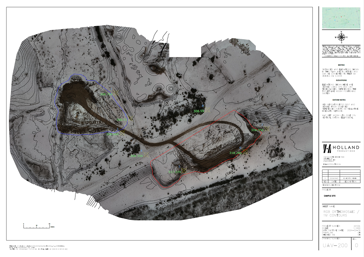
Precision Stockpile Analysis
Our advanced photogrammetry software generates detailed 3D models with precise volume calculations. Each stockpile is mapped with centimeter-level accuracy, providing you with exact measurements for inventory management.
- ✓ Color-coded elevation mapping
- ✓ Automated volume calculations
- ✓ Export-ready reports and data

RGB vs DSM Orthomosaic Comparison
Toggle between standard RGB imagery and Digital Surface Model (DSM) views to see how we transform aerial data into actionable volumetric insights.
Our Streamlined Survey Process
From consultation to delivery, we ensure precision at every step
Initial Consultation
We understand your requirements, gather site information, and identify specific areas of interest for the volumetric survey.
Survey Planning
Determine optimal flight paths, GCP locations, and safety protocols tailored to your site's unique requirements.
Aerial Data Collection
Our certified pilots deploy RTK-enabled drones to capture high-resolution imagery with precise ground control.
Processing & Analysis
Using advanced Pix4D software, we create detailed 3D point clouds and calculate precise volumes.
Report Delivery
Receive comprehensive reports with volume calculations, 3D models, and actionable insights for your operations.
Industry-Leading Advantages
Experience the future of stockpile measurement with Holland Productions
50% Time Reduction
Complete surveys in hours, not days
Cost Effective
Reduce labor costs and equipment needs
Enhanced Safety
No need for personnel in hazardous areas
Survey-Grade Accuracy
Centimeter-level precision with RTK GPS
Regular Monitoring
Track inventory changes over time
Complete Coverage
Capture entire sites without blind spots
Ready to Revolutionize Your Volumetric Surveys?
Get accurate stockpile measurements with our advanced drone technology
Schedule Your Survey Today