

Drone Data Processing
Professional photogrammetry and LiDAR processing to transform raw aerial data into actionable deliverables. Capture, processing, and delivery — all handled by the same team.
Request a Quote →Integrated Capture and Processing
At Holland Productions, the same team that plans and flies your project also handles the processing and delivery. This integrated approach means better communication, faster turnaround, and consistent quality from start to finish.
Whether we're processing RGB imagery into orthomosaics or LiDAR point clouds into terrain models, our team understands the full workflow — from flight planning through final deliverables.

The Integrated Advantage
Consistent Quality
The same team reviews and processes every dataset. We understand the capture conditions and can optimize processing accordingly.
Efficient Turnaround
With capture and processing under one roof, your project moves seamlessly from field to deliverables without handoff delays.
Clear Communication
One team, one conversation. Questions about your deliverables go directly to the people who captured and processed the data.
Data Types
RGB Imagery
LiDAR Point Clouds
Thermal / Infrared
Multispectral
Deliverables
2D Orthomosaics
Georeferenced aerial maps stitched from hundreds of overlapping images, accurate for measurement and analysis.
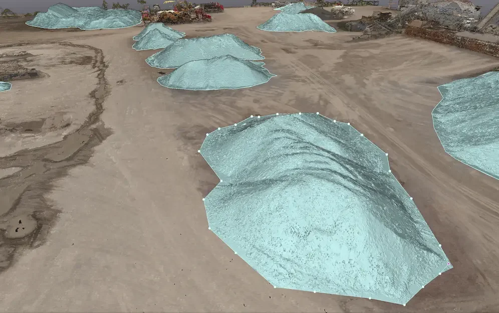
Point Clouds
Dense 3D point data from photogrammetry or LiDAR, delivered in LAS, LAZ, E57, or PLY formats.
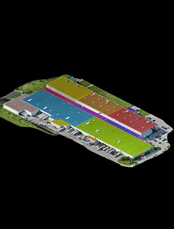
3D Models
Textured mesh models for visualization, measurement, and integration with CAD or BIM software.
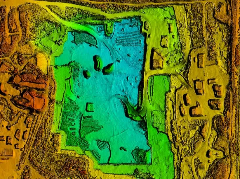
Digital Elevation Models
DSM and DTM products showing surface and terrain elevation for engineering and analysis.

Contour Lines
Custom interval contours extracted from elevation data, ready for CAD or GIS integration.

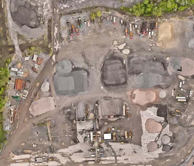
Volume Calculations
Stockpile volumes, cut/fill analysis, and material quantity reports with detailed breakdowns.
Our Processing Workflow
Data Ingestion
Import raw imagery or point cloud data with metadata and flight logs.
Quality Check
Review coverage, overlap, and data integrity before processing begins.
Processing
Align, georeference, and generate requested outputs using professional software.
Delivery
Export in your required formats and coordinate system, ready for use.
Formats & Integration
Output Formats
Compatible With
Common Questions
What data types can you process?
We process RGB imagery (photogrammetry), LiDAR point clouds, thermal/infrared imagery, and multispectral data. Whether captured by drone, aircraft, or ground-based systems, we can work with most standard formats.
Can you work with data we captured ourselves?
Yes. If you have your own drone data that needs processing, we can handle it. We'll review your imagery or point cloud data, discuss deliverable requirements, and provide a quote based on scope and complexity.
What coordinate systems do you support?
We can deliver in virtually any coordinate system — local grid, UTM, state plane, or custom project coordinates. Let us know your requirements and we'll match the output to your workflow.
How do you ensure accuracy?
Accuracy depends on capture method and ground control. For RTK/PPK flights with ground control points, we typically achieve 1-3 cm accuracy. We review every project for quality and can provide accuracy reports on request.
What software do you use?
We use industry-standard photogrammetry and LiDAR processing software including Pix4D, DJI Terra, and specialized point cloud tools. The specific workflow depends on project requirements and deliverables.
How long does processing take?
Turnaround depends on project size and complexity. Simple orthomosaics can be delivered within 1-2 business days. Larger projects with multiple deliverables may take 3-5 days. We'll provide a timeline estimate with your quote.
Can you create CAD-ready or BIM-ready deliverables?
Absolutely. We regularly deliver DXF, DWG, and other CAD formats. For BIM integration, we can provide point clouds and models compatible with Revit and other platforms. Let us know your software requirements.
Do you classify LiDAR point clouds?
Yes. We can classify point clouds into ground, vegetation, buildings, and other categories as needed. Classification level depends on project requirements and intended use.
Ready to Process Your Data?
Whether you need complete capture-to-delivery service or processing support for your own drone data, we're here to help.
Request a Quote →CONTACT
Request a Quote
Fill out the form below and we'll get back to you within one business day.