
Pix4D Matic's Enhanced Region of Interest (ROI) Tool with KML Import Feature
On This Page

Pix4DMatic .KML Import
Introduction
Updated March 28, 2024
Pix4D has released a stable version 1.58.1 as of March 18, 2024.
- - -
Pix4D released Matic Version 1.57.0, on February 28, 2024. This is a preview release and not a stable release.
The Region of Interest (ROI) feature was first added in the preview release version 1.26.0 on March 7, 2022. The stable release was 1.27.0 on March 28, 2022.
The ROI was added as a “tool for speeding up processing, reducing used disk space and cleaner outputs”. Indeed, looking back, it’s hard to imagine processing any 2D ortho-mosaics without using a region of interest. Why? Because the outside edges of the processed 2D orthomosaic will always have the least amount of overlap and therefore be blotchy and blurry. The results do not look professional, and we do not want our clients to see these results.
Even though we plan our drone mapping and drone inspection flight missions with enough margin overlap and the blurry edges are not within the desired map boundaries, we still don’t want these blurry parts showing up on our beautiful maps!
This is where the Region of Interest tool comes into play.
We are very excited about the new KML import feature that gives us the ability to import a KML directly from Google Earth Pro into Pix4DMatic as an ROI.
Understanding the Region of Interest Tool
As briefly mentioned in the intro, the Region of Interest tool is a way to restrict processing and output results to a region that you define. Before the latest preview release 1.57.0, the ROI was essentially a region that you draw in on your map.
There are a few reasons you may want to do this but the two most important reasons in my opinion are; to create cleaner edges on 2D orthomosaic Maps, and to create cleaner 3D models.
Naturally, by reducing the ROI of the project you are reducing the size of the processing dataset which will speed up processing times, reduce project size, reduce output file size and overall take up less disc space.
Another reason you may want to use the ROI is to restrict an area of the map for privacy concerns. However, this typically means you did not do your flight plan properly and these areas should not have been included in your mission planning at all. If this is the case, we recommend deleting the original images altogether and not just excluded from the project processing.
Cleaner Edges on Orthomosaic Maps
If you process your project without using a Region of Interest, the edges of the ortho-mosaic and DSM will not look clean. They will be jagged and blurry, as the very outer edges of the flight path will have the least amount of overlap.

Edges of 2D Orthomosaic
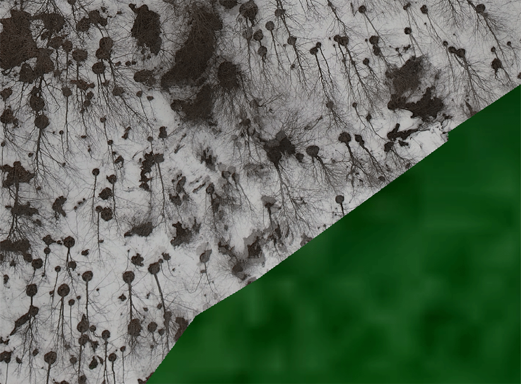
Blurry Edges of 2D Orthomosaic
Using the ROI tool will allow us to process and export cleaner edges, as we will discard the outermost boundary of the captured map.
Does the ROI Speed Up the Calibration Step?
No. Even though you can add or import the ROI just after the images have been added to the project, it does not affect the calibration step.
This means that all images included in the project will be calibrated, and not only the cameras within the Region of Interest.
What Processing Steps Does the ROI Affect?
The ROI affects all steps after the calibration step.
These steps are:
Dense Point Cloud
Image Pre-processing
Planes
Mesh
DSM
Orthomosaic
Exports
Can You Use the ROI to Restrict Only the Exports?
No. Unfortunately, you cannot use the Region of Interest to restrict a smaller portion of the processed data on just the export. Meaning, that if a specific ROI is required on the export, this ROI should be set before the processing steps. Adding the ROI after processing is complete, will not affect the outputs.
Version 1.57.0 KML file import feature for defining ROI.
One of our favourite new features in Version 1.57.0 is the ability to import a KML file into Matic as a Region of Interest. This is a very useful feature for our workflow with our technical clients who provide KML files to us.
We receive the KML file from our clients from Google Earth Pro for our drone flight mission planning. Once we receive the KML, we import it into our Google Earth Pro and do our desktop study. From here we import the KML into our flight controller to plan our mission with the drone and payload.
Since the KML is the outer boundary of the mapping area, we plan a margin boundary with overlap to ensure we capture the edge of the KML with the center of the payload lens or better, ensuring adequate overlap of the KML lines.
Once the data is captured, we import the images into Pix4D Matic. We calibrate the cameras and review the data.
From here, we can now import the same KML file into the Matic project as a Region of Interest! Now we can be guaranteed that the processing steps and final outputs will be exactly to our client's KML file with clean edges.
We know the edges will be clean because we took the time to ensure our margins were set correctly about the KML, flight altitude and overlap.
“By reducing the ROI of the project you are in fact reducing the size of the processing dataset which will speed up processing times, reduce project size, reduce output file size and overall take up less disc space. ”
Step-by-Step Guide
Step 1: Draw the ROI Polygon In Google Earth Pro
Using the polygon tool, draw the ROI.

Using the polygon tool, draw the ROI in Google Earth Pro
Step 2: Export KML from Google Earth Pro

Right Click on the Polygon and Click Save Place As…

Ensure you chose .kml as the file type, not .kmz
Choose the file location to save the polygon boundary as a KML, not KMZ.
Step 2: Import KML Into Matic as a Region of Interest (ROI)
In Matic choose File>Import>Region of Interest

File>Import>Region of Interest
The .kml file is now imported into the Matic project as the region of interest.

.kml as the Region of Interest
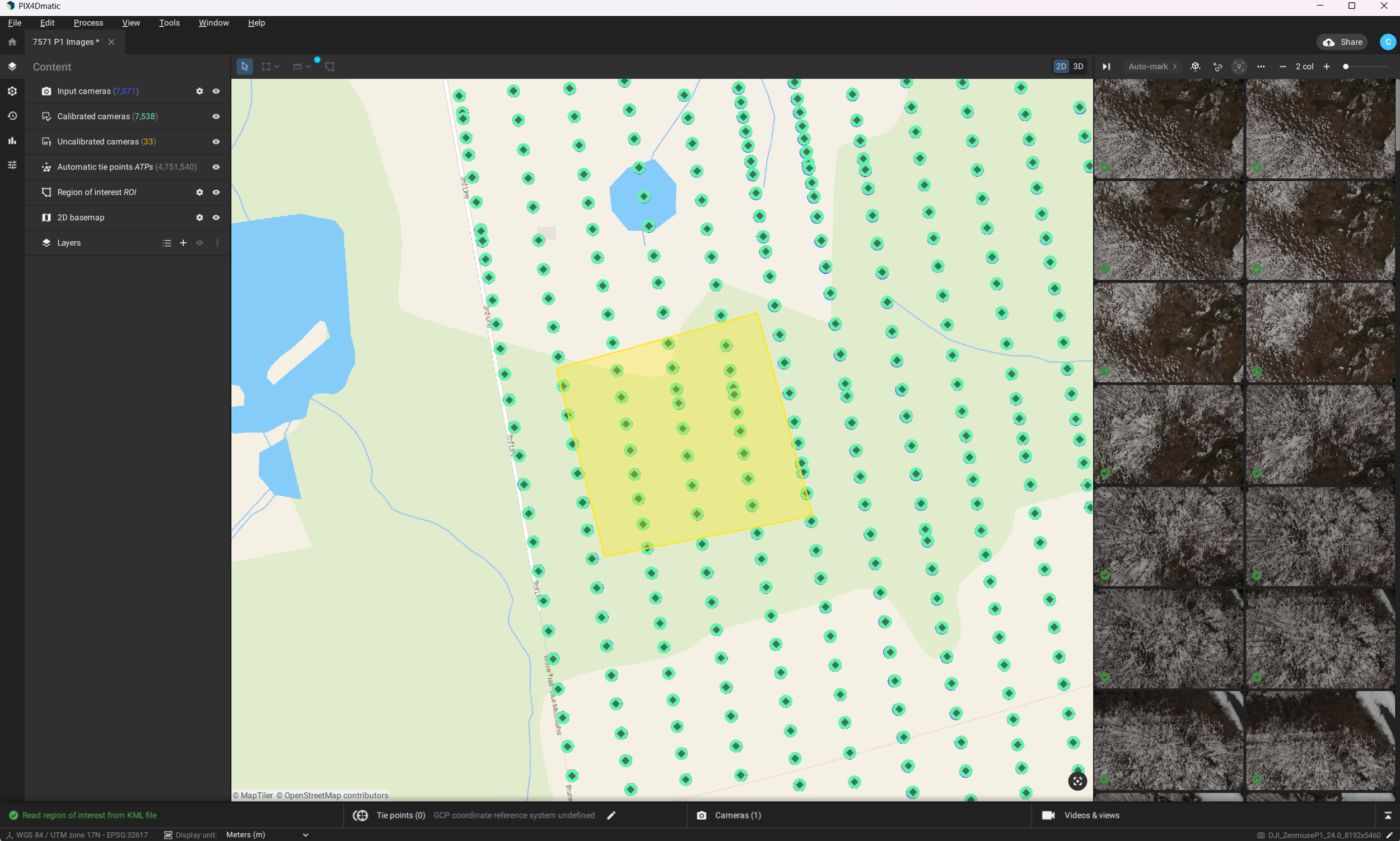
Zoomed view of the .kml as the Region of Interest
Once the 2D Ortho-mosaic is processed using the ROI, you can see how much cleaner the edged are.

Conclusion
The Region of Interest (ROI) tool in Pix4D Matic is a great way have professional looking 2D ortho-mosaic maps as well as 3D Models.
The nature of UAV data capture will have low image overlap near the very outside edges of the flight mission. This leads to very undesirable edges to maps and models.
By utilizing the .kml import feature as a Region of Interest in Pix4DMatic, you can ensure that the boundaries set by your client will be carried throughout the flight mission planning, data processing and deliverables with clean edges to maps and models.