
3D Scanning Services
Aerial photogrammetry, SLAM scanning, LiDAR, and Gaussian splatting to create precise 3D models for architecture, heritage preservation, and construction projects.
Get a Free Quote3D Scanning Technologies
Multiple capture methods to match your project requirements, accuracy needs, and budget.
Aerial Photogrammetry
Drone-based capture for large outdoor sites, buildings, and terrain using overlapping imagery.
Drone LiDAR
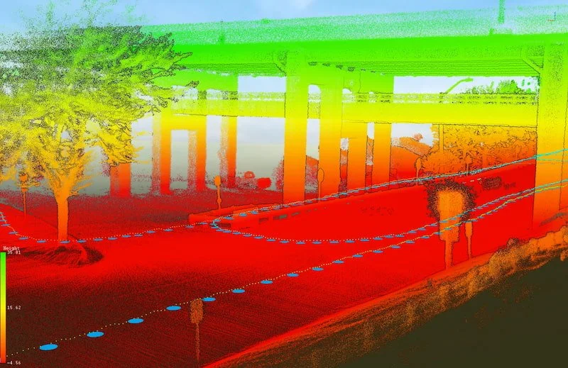
High-precision point clouds for topographic mapping, vegetation penetration, and corridor mapping.
SLAM Scanning
Handheld mobile scanning for interiors, confined spaces, and complex structures.
Point Cloud Processing
Transform raw scan data into cleaned, registered, and deliverable-ready point clouds.
Textured 3D Models
Photorealistic mesh models with high-resolution textures for visualization and inspection.
Gaussian Splatting
Next-generation photorealistic rendering for immersive 3D visualization experiences.
Aerial Photogrammetry
Capture entire buildings, sites, and landscapes with drone-based photogrammetry. Our automated flight missions capture hundreds of overlapping images to construct detailed 3D models with photorealistic textures.
- Buildings & Structures
- Heritage Sites
- Construction Sites
- Terrain Mapping
- Industrial Facilities
SLAM Scanning
Capture complex interiors and confined spaces with our handheld SLAM scanner. Walk through any environment to capture millions of points per second, creating comprehensive 3D documentation in spaces where drone flight is impractical or cost-prohibitive.
- Building interiors and atriums
- Mechanical rooms and basements
- Tunnels and underground facilities
- Historical building preservation
- Rapid as-built documentation
Gaussian Splatting
Experience the future of 3D visualization. Gaussian splatting creates photorealistic, immersive models that look almost indistinguishable from reality — perfect for presentations, marketing, and stakeholder engagement.
- Photorealistic rendering
- Interactive viewing
- Marketing presentations
- Heritage documentation
- Virtual tours
Interactive 3D Models
Explore our work. Click and drag to rotate, scroll to zoom.
Heritage Church
Detailed exterior capture for heritage preservation documentation.
Textured MeshWater Tower
Industrial infrastructure documentation with photorealistic textures.
Textured MeshHotel Exterior
Commercial building facade documentation for renovation planning.
Textured MeshWater Tower (Gaussian Splat)
Next-generation photorealistic visualization using Gaussian splatting.
Gaussian SplatWho We Work With
Trusted by professionals who need accurate, detailed 3D documentation.
Benefits of
3D Documentation
Accurate, efficient, and versatile capture for any project requirement.
Accuracy
Millimeter-level precision for engineering, design, and documentation requirements.
Speed
Capture entire buildings in hours, not days. Faster data collection means faster project delivery.
Visualization
Photorealistic 3D models for presentations, client communication, and stakeholder buy-in.
Deliverables
Multiple output formats: point clouds, meshes, orthophotos, CAD-ready files, and interactive viewers.
Frequently Asked Questions
What's the difference between precision and accuracy?
Precision refers to how repeatable measurements are — how close multiple measurements of the same point are to each other. Accuracy refers to how close measurements are to the true real-world position. A high-accuracy project needs both high precision and high accuracy. Visual documentation projects may prioritize precision (consistent model) over absolute accuracy.
When do textures matter more than measurements?
Inspection and visual documentation projects prioritize detailed, photorealistic textures so you can see surface conditions, defects, and materials. Design/build projects prioritize geometric accuracy for CAD integration and measurement extraction. We tailor our capture approach based on your project's primary use case.
Which scanning method is right for my project?
Aerial photogrammetry: Large outdoor sites, building exteriors, terrain. Drone LiDAR: Vegetated areas, topographic mapping, corridor mapping. SLAM scanning: Interiors, confined spaces, rapid as-builts. Terrestrial laser: Highest precision for engineering-grade requirements. Often we combine methods for complete coverage.
What file formats do you deliver?
We deliver in multiple formats based on your needs: Point clouds (LAS, LAZ, E57, PLY), Meshes (OBJ, FBX, GLB), Orthophotos (TIFF, JPG), CAD-ready files, and interactive NIRA viewer links for easy sharing with stakeholders who don't have specialized software.
How accurate is drone photogrammetry vs laser scanning?
Drone photogrammetry with ground control points typically achieves 1-3 cm accuracy horizontally and 2-5 cm vertically. Terrestrial laser scanning achieves millimeter-level accuracy (1-3 mm). Drone LiDAR with RTK positioning achieves 2-5 cm accuracy. We recommend the appropriate method based on your project's accuracy requirements and budget.
Ready to Capture Your Project?
Get accurate 3D documentation for your building, site, or asset. We'll recommend the right capture method for your needs.
Request a QuoteCONTACT
Request a Quote
Fill out the form below and we'll get back to you within one business day.