

LiDAR Mapping Georgian Bay
High-precision terrain mapping for shoreline properties and coastal sites across Georgian Bay's rugged landscape.
Request a Quote →Mapping Georgian Bay's Unique Terrain
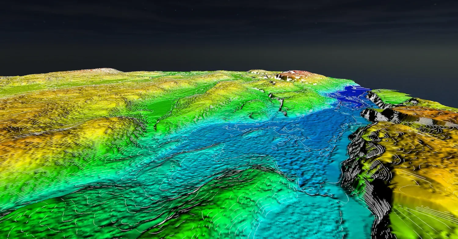
Georgian Bay's landscape is unlike anywhere else in Ontario. The iconic windswept pines, exposed Canadian Shield granite, and intricate shoreline create spectacular settings for waterfront properties. They also create significant challenges for site development and construction planning.
Drone LiDAR is ideal for this terrain. Our sensors map rock outcrops, elevation changes, and forest cover in a single flight, providing complete terrain data for shoreline properties and coastal sites.
Whether you're planning a new build on the coast, documenting shoreline conditions, or designing infrastructure for a challenging site, LiDAR delivers precision data that makes informed decisions possible.

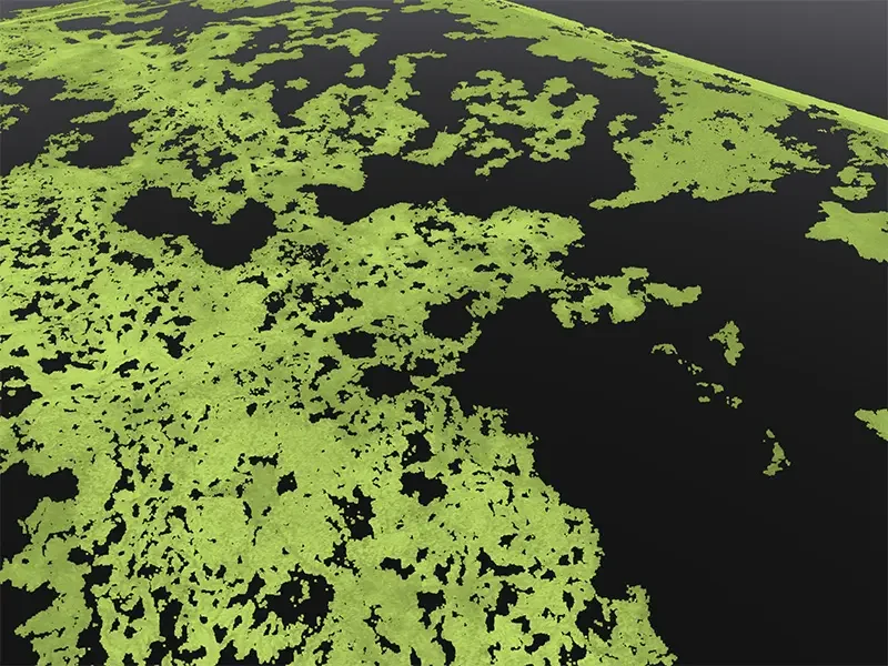
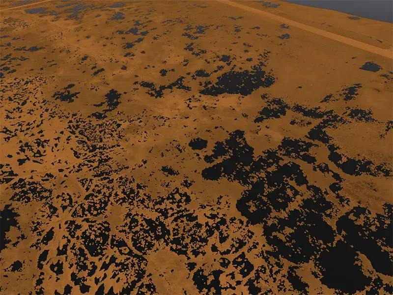
Full Point Cloud vs Bare Earth
< SLIDE TO COMPARE >

Full classified point cloud with vegetation vs bare earth terrain model showing ground surface.
LiDAR Applications on Georgian Bay
Precise terrain data for coastal and shoreline properties
Coastal Site Mapping
Complete terrain data for waterfront properties. Map the full extent of your shoreline lot in a single flight.
Rock Outcrop Documentation
Map exposed granite formations and buildable areas. Critical for foundation planning on Shield terrain.
Shoreline Documentation
Capture coastal elevation, bank conditions, and erosion patterns. Baseline data for permit applications.
Construction Planning
Topographic data for building placement on uneven terrain. Identify flat areas and design around rock.
Septic Site Assessment
Find suitable soil areas on rocky properties. Elevation data for challenging septic installations.
Drainage Analysis
Model water flow across bedrock terrain. Identify natural drainage paths and potential issues.
Mapping the Shield
Georgian Bay's exposed bedrock and sparse vegetation create unique mapping challenges. LiDAR captures the detail that matters.
Maps Rock Surfaces
Captures detailed elevation of exposed bedrock, crevices, and uneven terrain.
Penetrates Sparse Canopy
Maps ground beneath windswept pines and mixed vegetation typical of the coast.
Survey-Quality Accuracy
2-5cm vertical accuracy for engineering design and construction planning.
Coastal Access
Fly over water-access-only properties. No need for boat transport of ground crews.
LiDAR vs Photogrammetry
< SLIDE TO COMPARE >
Same forest area: Photogrammetry ground points limited by canopy. LiDAR penetrates to map the ground.
Survey-Quality LiDAR Systems
DJI Zenmuse L3
Up to 350,000 points per second with integrated RTK. Maps both rock surfaces and vegetated areas with precision.
DJI Matrice 400 RTK
Heavy-lift platform with extended flight time. Essential for covering large coastal sites.
RTK/PPK Processing
Survey-quality positioning using NRCAN PPP. Accurate even on remote sites without local base stations.
Georgian Bay Coverage
We serve coastal and shoreline properties throughout Georgian Bay, from the southern reaches near Midland to Parry Sound and beyond.
Also Serving Cottage Country
For remote or difficult-access properties, contact us to discuss logistics.
Deliverables
Classified Point Cloud
Ground, vegetation, rock, and structures separated. LAS/LAZ format.
Digital Terrain Model
Bare earth and rock surface. GeoTIFF format for CAD and GIS.
Contour Lines
AutoCAD-ready contours capturing terrain detail.
Orthomosaic
High-resolution aerial imagery of your property.
LiDAR Mapping Georgian Bay
Can you reach remote or difficult-access properties?
We can survey properties that are difficult to access by ground, as long as we can reach a suitable launch location. Contact us to discuss your specific site and we'll determine the best approach.
How does LiDAR work on rocky terrain?
LiDAR maps hard surfaces like exposed granite just as well as vegetated areas. The sensor captures precise elevation data on rock outcrops, helping you identify buildable areas and plan around challenging features.
How much does a Georgian Bay survey cost?
Pricing depends on property size, location, and access logistics. Contact us with your property details for a quote.
What accuracy can I expect?
With RTK/PPK positioning, we achieve 2-5cm vertical accuracy on both rock and vegetated surfaces. This is suitable for engineering design and construction planning.
How do you handle shoreline mapping?
We capture terrain data right to the water's edge. Water surfaces appear as data voids in the point cloud, clearly defining your shoreline. For best results, we schedule flights during calm water conditions.
What's the turnaround time?
Most properties require 30 to 90 minutes of flight time. We can typically complete field work in a single visit. Data processing and deliverable preparation takes 5 to 7 business days.
Request Your Georgian Bay LiDAR Quote
Accurate terrain data for your coastal property. Tell us about your site and we'll provide a detailed quote.
Request a Quote →Questions? Reach us at 1-416-797-4870 or info@hollandproductions.ca