

LiDAR Mapping Haliburton
High-precision terrain mapping for remote builds, challenging sites, and forested properties across the Haliburton Highlands.
Request a Quote →Mapping Remote and Rugged Terrain
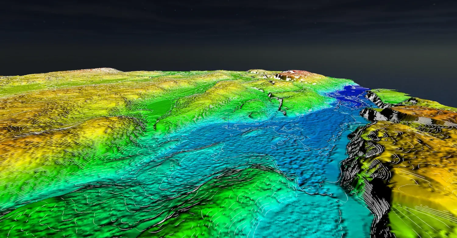
Haliburton Highlands presents some of Ontario's most challenging terrain for development. Rolling hills, dramatic elevation changes, dense hardwood forest, and limited road access make traditional ground surveys expensive and time-consuming.
Drone LiDAR is built for exactly these conditions. Our sensors penetrate thick canopy to map the actual ground surface, capturing terrain data across your entire property efficiently.
Whether you're planning a new build on a secluded lot, documenting a waterfront site, or designing infrastructure for a challenging property, LiDAR delivers the precision topographic data you need.

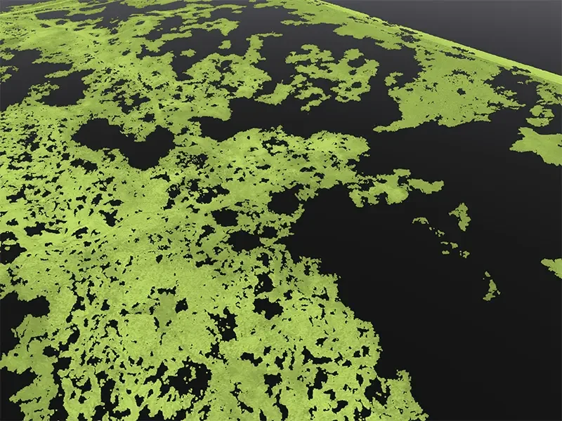
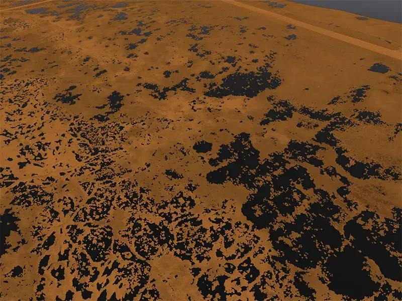
Full Point Cloud vs Bare Earth
< SLIDE TO COMPARE >

Full classified point cloud with vegetation vs bare earth terrain model showing ground surface.
LiDAR Applications in Haliburton
Precise terrain data for challenging highland properties
Remote Site Planning
Complete topographic data for building sites with limited access. Know your terrain before committing to construction.
Elevation Mapping
Capture dramatic terrain changes across your property. Critical data for building placement and foundation design.
Septic System Design
Precise slope and elevation data for challenging septic installations. Meet health unit requirements on difficult terrain.
Access Road Design
Plan driveways and access routes through hilly terrain. Calculate grades and cut/fill volumes accurately.
Drainage Analysis
Model water flow across uneven terrain. Identify drainage challenges before they become construction problems.
Forest Assessment
Map vegetation density and canopy height. Plan selective clearing while preserving mature growth.
Mapping Through Dense Forest Cover
In Haliburton's dense hardwood and mixed forest, aerial photography captures treetops, not terrain. LiDAR captures the ground beneath.
Penetrates Dense Canopy
Laser pulses find gaps in thick forest to map the actual ground elevation beneath.
Captures Elevation Detail
Critical for Haliburton's rolling terrain. See every ridge, depression, and slope change.
Survey-Quality Accuracy
2-5cm vertical accuracy for engineering design and construction planning.
Remote Access
Fly over difficult terrain. No need to cut sight lines or carry equipment through bush.
LiDAR vs Photogrammetry
< SLIDE TO COMPARE >
Same forest area: Photogrammetry ground points limited by canopy. LiDAR penetrates to map the ground.
Survey-Quality LiDAR Systems
DJI Zenmuse L3
Up to 350,000 points per second with integrated RTK. Our primary sensor for terrain mapping in dense forest.
DJI Matrice 400 RTK
Heavy-lift platform with extended flight time. Essential for covering large, remote Haliburton properties.
RTK/PPK Processing
All data georeferenced using NRCAN PPP or local base stations for survey-quality positioning.
Haliburton Highlands Coverage
We serve properties throughout Haliburton County, from the lakes around Minden to remote sites in the northern highlands.
Also Serving Cottage Country
For very remote properties, contact us to discuss access and logistics.
Deliverables
Classified Point Cloud
Ground, vegetation, and structures separated. LAS/LAZ format.
Digital Terrain Model
Bare earth surface with vegetation removed. GeoTIFF format.
Contour Lines
AutoCAD-ready contours at specified intervals.
Orthomosaic
High-resolution aerial imagery captured with LiDAR.
LiDAR Mapping Haliburton
How much does LiDAR mapping cost in Haliburton?
Pricing depends on site size, terrain complexity, and travel distance. Contact us with your property details for a specific quote.
Can you access remote properties?
Yes. Our drone-based approach is well-suited to remote sites. We need a safe launch area with clear sky above, and can efficiently cover properties with limited access.
How well does LiDAR work in dense forest?
Very well. LiDAR pulses find gaps in even dense hardwood canopy. In typical Haliburton forest, we achieve sufficient ground returns for accurate terrain modeling.
What accuracy can I expect?
With RTK/PPK positioning, we achieve 2-5cm vertical accuracy and 2-3cm horizontal accuracy, suitable for engineering design and construction planning.
How long does a survey take?
Flight time varies by property size. Most sites require 45 to 90 minutes of flying. We can typically complete field work in a single visit. Data processing takes 5 to 7 business days.
Do you work year-round?
Yes. LiDAR works well in late fall and winter when leaves are off deciduous trees, allowing even better ground penetration. Snow cover will affect results, so we schedule flights for snow-free conditions when possible.
Request Your Haliburton LiDAR Quote
Accurate terrain data for your highland property. Tell us about your site and we'll provide a detailed quote.
Request a Quote →Questions? Reach us at 1-416-797-4870 or info@hollandproductions.ca