

LiDAR Mapping Parry Sound
High-precision terrain mapping for wilderness properties, large acreages, and remote sites across the Parry Sound District.
Request a Quote →Terrain Data for Remote Properties
The Parry Sound District offers some of Ontario's most spectacular wilderness properties. Large acreages, remote locations, and dense mixed forest make traditional ground surveys impractical and expensive. Drone LiDAR changes the equation entirely.
Our aircraft cover large properties efficiently, penetrating thick forest canopy to map the actual ground surface below. For remote sites accessible only by water or rough road, drone-based LiDAR provides comprehensive coverage.
Whether you're planning a wilderness retreat, documenting a large property for development, or assessing terrain for resource management, LiDAR delivers the comprehensive elevation data you need.

Full Point Cloud vs Bare Earth
< SLIDE TO COMPARE >

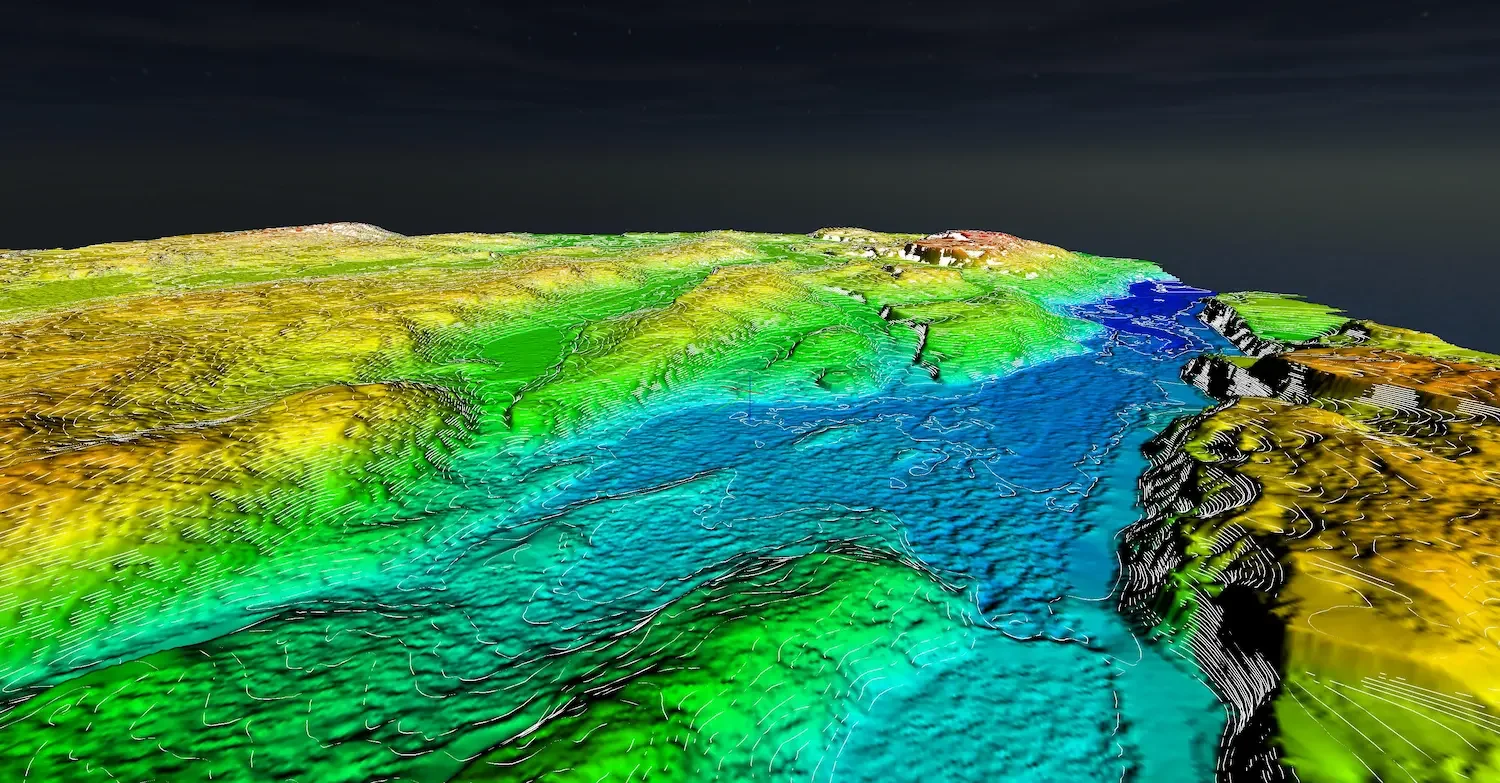
Full classified point cloud with vegetation vs bare earth terrain model showing ground surface.
LiDAR Applications in Parry Sound
Precision terrain data for wilderness and large-acreage properties
Large Acreage Mapping
Efficient coverage of large properties from 100 to 1,000+ acres. Comprehensive terrain data for extensive sites.
Remote Site Assessment
Evaluate building sites, access routes, and terrain features on properties with limited or no road access.
Construction Planning
Complete topographic data for wilderness builds. Identify flat areas, rock outcrops, and optimal building locations.
Road & Trail Planning
Design access routes through challenging terrain. Calculate grades and identify the best path through forested land.
Forest Assessment
Map terrain and canopy structure. Support forest management decisions with accurate elevation and vegetation data.
Watershed Analysis
Model drainage patterns across large properties. Identify water features, flow paths, and wetland areas.
Mapping Large Properties Efficiently
For Parry Sound's expansive wilderness properties, LiDAR provides complete coverage that would be impossible with traditional methods.
Penetrates Dense Forest
Laser pulses reach the ground through thick mixed forest canopy typical of the region.
Large Area Coverage
Map hundreds of acres efficiently. Extended flight time covers big properties in fewer missions.
Survey-Quality Accuracy
2-5cm vertical accuracy for engineering design and construction planning.
Remote Access
Reach properties accessible only by water or rough road. No ground crew transport required.
LiDAR vs Photogrammetry
< SLIDE TO COMPARE >
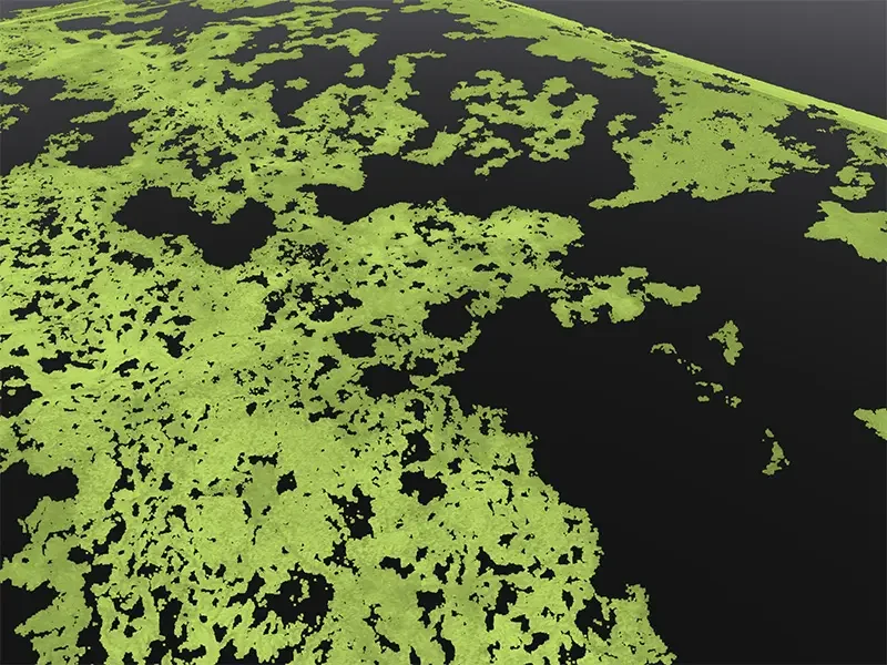
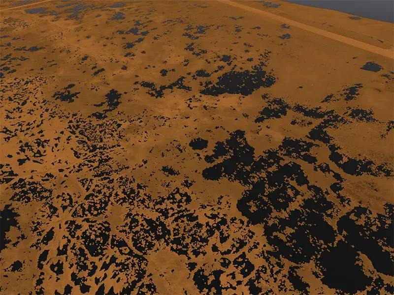
Same forest area: Photogrammetry ground points limited by canopy. LiDAR penetrates to map the ground.
Survey-Quality LiDAR Systems
DJI Zenmuse L3
Up to 350,000 points per second with integrated RTK. Excellent canopy penetration for dense forest conditions.
DJI Matrice 400 RTK
Heavy-lift platform with extended 45-minute flight time. Essential for covering large Parry Sound properties.
RTK/PPK Processing
Survey-quality positioning using NRCAN PPP. Accurate even in remote areas without cell coverage.
Parry Sound District Coverage
We serve properties throughout the Parry Sound District, from the southern areas near Rosseau to the northern reaches around Sundridge and beyond.
Also Serving Cottage Country
We travel throughout Northern Ontario for large LiDAR projects. Contact us for remote locations.
Deliverables
Classified Point Cloud
Ground, vegetation, and structures separated. LAS/LAZ format.
Digital Terrain Model
Bare earth surface for engineering and analysis. GeoTIFF format.
Contour Lines
AutoCAD-ready contours at specified intervals.
Orthomosaic
High-resolution aerial imagery of your property.
LiDAR Mapping Parry Sound
Can you map very large properties?
Yes. Our equipment and workflow are designed for large acreages. We regularly map properties of 800 to 1,200 acres and can handle larger sites. Extended flight times and efficient flight planning make large-scale coverage practical.
How do you access remote properties?
We can access properties by road, boat, or ATV depending on conditions. For very remote sites, we coordinate logistics with you in advance to ensure we can reach a suitable launch location.
How much does large-acreage LiDAR cost?
Pricing depends on property size, location, and deliverables. Per-acre costs decrease significantly for larger properties. Contact us with your acreage and location for a detailed quote.
What accuracy can I expect?
With RTK/PPK positioning, we achieve 2-5cm vertical accuracy even on large, remote properties. This is suitable for engineering design and construction planning.
How long does a large property take?
Flight time scales with property size. A 250-acre property typically requires 2-3 hours of flying. Processing time for large datasets is typically 1-2 weeks depending on deliverables.
Do you work in winter?
Late fall and early winter with leaf-off conditions are excellent for LiDAR in deciduous forest, as ground penetration improves significantly. However, snow cover will affect results, so we schedule flights for snow-free conditions when possible.
Request Your Parry Sound LiDAR Quote
Comprehensive terrain data for your wilderness property. Tell us about your site and we'll provide a detailed quote.
Request a Quote →Questions? Reach us at 1-416-797-4870 or info@hollandproductions.ca